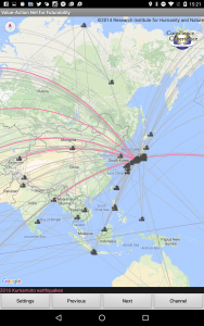
Have a look at the automatically-updated earthquakes map, a sub-channel for “ch059: the 2016 Kumamoto earthquakes” that has been added. Thanks to the USGS’s Earthquakes Hazard Program and the Generic Mapping Tools (GMT), real-time feeds on earthquake information are available to every user of the Value-Action Net for Futurability.
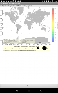
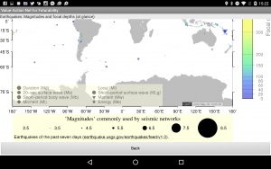
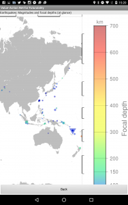
At this time, the magnitudes and focal depths of earthquakes of the past seven days are visualised on the world map (updated every 2 hours). We’d like to add more practical data to the map upon your request.
I have already written up several GMT scripts (in conjunction with UNIX shell scripts) and ad hoc App server programmes, hence this scheme should readily be applicable to other sources such as climate data, biodiversity indices, and measures of chemical pollution.
Ch059 熊本地震(2016年)のサブチャンネルとして、世界の地震情報を掲載しました。米国地質調査所の地震災害プログラムとソフトウェアGMTのかげで、地震に関するリアルタイムの情報を「環境観でつながる世界」のユーザにお届けできます。
現時点での地震情報は、過去7日間のマグニチュードと震源の深さを世界地図に可視化しています。リクエストに応じて、より実用的な情報を加える予定です。
GMT関連のスクリプトとサーバプログラムを構築していますので、このスキームは気候データなどにも応用可能です。